
Google Maps is without question the most popular navigation app, with globally 67% of people using Google Maps, compared to 12% using Waze and 11% using Apple Maps. Because of this, Google is constantly looking for ways to further improve its navigation app for users to stay ahead of its competitors. That’s why they’ve taken steps to address a common issue with navigating around cities.
The blue dot on Google Maps shows where you are standing, but it can actually end up being a long way off from where you actually are because large buildings can block GPS signals and your phone’s compass being disrupted by the metal surroundings of an urban city. This can cause issues when trying to navigate as the blue dot is constantly repositioning and can’t work out exactly where you are.
To rectify this issue and improve user experience, Google is introducing an innovative Augmented Reality system known as ‘Global Localization’.
Enhancing on-foot city navigation with AR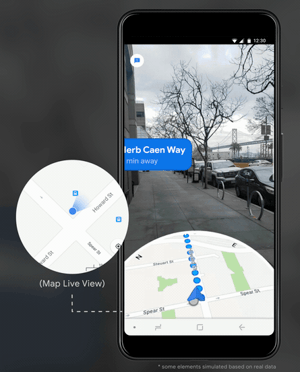
Augmented Reality technology is used to help locate your exact position when walking around a new city by bringing together visual positioning, Google Street View and machine learning into a single effective product. The result is a much more helpful navigation solution that lets you know exactly where you need to go when navigating around a city without the blue dot wondering off all over the place.
The system uses the camera in your smartphone to ‘see’ your surroundings allowing the app to know exactly where you are by recognising buildings and can then give you clear instructions to your desired destination as a result.
Information is then presented to the user such as distance to your location, predicted arrival time and arrows pointing you in the right direction to make the navigation process easy and more accurate.
Global Localization safety features
To avoid any accidents (and to cover Google legally) there a number of safety features. The Google Maps Global Localization system will prompt you to put your phone down and pay attention to your surroundings when using the app and if you ignore these warnings then the app will automatically turn off the Augmented Reality effect.
This prevents you from entirely relying on your phone screen to guide you and should, therefore, reduce the issue of people bumping into each other, walking into lampposts or even worse strolling straight out into the traffic.
Enhancing on-foot city navigation with AR
So, can you use these new features? Not yet and probably not for a while.
Google is still working on this technology and has only rolled it out to a select number of Local Guides who will test the Global Localization features and feedback their thoughts to Google.
For Global Localization to work, Street View has to be completely accurate with the real world. For example, if a new building has been built since the last Google Street View drive through, then this could confuse the system. This then creates a real challenge for Google, as to ensure their data is as accurate, they will need to be constantly refreshing and updating their system.
We’ll have to wait for the Local Guides to share their views and for Google to iron out any issues before we’ll be able to use these new features on our smartphones, but this latest update should certainly make navigating around a city we’re not familiar with much, much easier.
Engadget took a first look at Google Maps use of AR technology in this video:


-1.png?width=250&height=141&name=image-gen%20(1)-1.png)


